El Capitan Beach and Refugio Beach
Santa Barbara County

El Capitan State Beach and
Refugio State Beach
Location
Highway 101
17 - 20 miles west of Santa Barbara
(805) 968-1033
Admission
Day use per vehicle: $10
Park Hours: 8:00 AM to dusk
Main Attractions
- Surfing
- Camping
- Picnicking
- Beach walking
Facilities and Features
- Parking, restrooms
- Campgrounds
- Showers
- Hiking trails
- Lifeguards during peak season
Accessibility
- Campsites, restrooms
- Picnic area
- Beach wheelchair available at entry station. At Refugio Beach call (805) 968-1033 to reserve beach wheelchair
- Bluff-top bike/walkway trail
- Nature Trail at El Capitan
- Campfire Center
Hazards
- Rogue waves
- Rip currents
- Rising tides trapping beach walkers against cliffs
- Dangerous cliffs
Special Regulations
- Dogs on leash in campground
- No dogs on beach or trails
Nearby Beaches
- Gaviota State Park, 9 - 12 miles northwest
- Jalama Beach County Park, 39 - 42 miles north
- Goleta Beach, 13 - 17 miles south
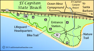
El Capitan State Beach
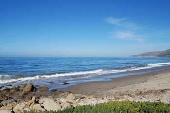
Only a half hour drive up the coast from Santa Barbara, El Capitan Beach sees a lot of visitors year-round. Among favorite activities along the rock and sand beach are surfing, exploring tide pools, picnicking, sun bathing, and fishing.
A bike-walk trail meanders along the coast, provide great views of the ocean. Clusters of campgrounds along the shore make it a popular destination for campers.
El Capitan Beach property extends across the railroad tracks and Highway 101 up into the lower slopes of the Santa Ynez Mountains, but most visitors confine themselves to the beach areas. A nature trail and a rolling bike-walk trail offer great ways to explore the coast and the forested areas along El Capitan Creek.
Wildlife
A variety of birds can be spotted in the trees. Among the most common are scrub jays, flickers, California thrashers, and band-tailed pigeons. Squirrels scurry about the tree limbs while mule deer forage among the oaks and shrubs. Out along the coast birders spot gulls, loons, Clark's grebes, and scoters. Looking out to sea, you may well see dolphins and passing gray whales.
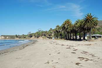
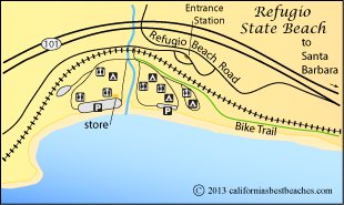
Refugio State Beach
Three miles up the coast from El Capitan State Beach, palm tree-lined Refugio State Beach rests in a shallow cove. Its sandy beach attracts sun bathers and picnickers, beach walkers and anglers. During the summer months lifeguards are on duty.
Key Features at Refugio State Beach
- Mile-long sandy beach
- Campground close to beach
- Kayak Tours led by lifeguards
- Plenty of picnic tables and BBQs
- General store open on weekends
A coastal bike and walk trail connects Refugio State Beach with El Capitan State Beach, 3 miles down the coast.
Refugio State Beach
From the bluffs along the edge of the ocean visitors can get a great view of the Channel Islands. Walking along the 1.5-mile long beach can lead to many wonders. Harbor seals can be spotted bobbing in the surf. The tide pools are filled with rich colonies of sea stars, sea anemones, crabs, and other interesting creatures.
Some people like to swim in the freshwater lagoon formed where Refugio Creek empties into the ocean.
Nearby Beaches
Ocean Safety
California State Parks and Recreation cautions that "large surf, cold water temperatures, backwash, sudden drop-offs,
pounding shorebreak, and dangerous rip currents can turn what seem like safe activities such as
playing near the surf line, wading, or climbing on rock outcroppings, deadly."
Learn more about ocean safety at
CA State Parks: Ocean Safety
California's Best Beaches
Every effort is made to provide accurate and up to date information, but we cannot be responsible for errors or for changes that may have occurred since publication. Always confirm information with the service provider and check for any recent changes that may have been made. Also, check with lifeguards that conditions at the beach are safe for your planned activities.
The map displayed above is for illustrative purposes only. California's Best Beaches website makes no warranties regarding the accuracy, completeness, reliability or suitability of any of its maps. The information provided on this website is done so without warranty of any kind, either expressed or implied, including but not limited to, the implied warranties of merchantability and fitness for a particular purpose.