El Capitan Beach &
Refugio Beach Directions
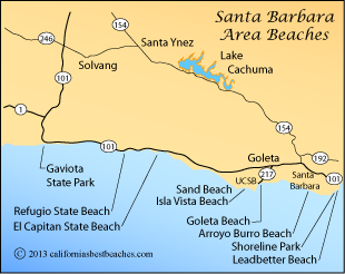
Santa Barbara County

Mileages and Driving Times to El Capitan Beach, Santa Barbara County
| City | Miles | Hrs/Mins |
|---|---|---|
| Bakersfield | 163 | 2:55 |
| Fresno | 230 | 3:40 |
| Lompoc | 36 | 0:37 |
| Los Angeles | 113 | 1:43 |
| Monterey | 231 | 3:33 |
| Paso Robles | 115 | 1:50 |
| San Jose | 272 | 3:59 |
| San Luis Obispo | 88 | 1:11 |
| San Francisco | 319 | 4:42 |
| Santa Barbara | 18 | 0:19 |
| Santa Maria | 57 | 1:07 |
| Ventura | 46 | 0:49 |
California's Best Beaches
Every effort is made to provide accurate and up to date information, but we cannot be responsible for errors or for changes that may have occurred since publication. Always confirm information with the service provider and check for any recent changes that may have been made. Also, check with lifeguards that conditions at the beach are safe for your planned activities.
The map displayed above is for illustrative purposes only. California's Best Beaches website makes no warranties regarding the accuracy, completeness, reliability or suitability of any of its maps. The information provided on this website is done so without warranty of any kind, either expressed or implied, including but not limited to, the implied warranties of merchantability and fitness for a particular purpose.