Mendocino Headlands & Big River Beach
Mendocino County

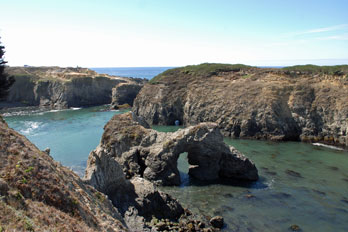
Mendocino Headlands State Park
Location
- Mendocino, CA
- Open 6:00 AM to sunset
- (707) 937-5804
- Free
Main Attractions
- Bluff-top trails
- Rugged coastline, grottos, sea arches
- Secluded beaches
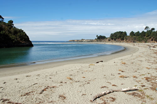
- Big River Beach
- Diving, snorkeling
Facilities
- Parking
- Restrooms
- Historic Ford House museum
- Big River Wetlands
- Hiking and Equestrian trails
- Picnic Area
Accessibility
- Some trails
- Parking, restrooms
Hazards
- Crumbling cliff edges
- Rogue waves
- Rip-currents
- Cold water
Caution: Check with rangers or lifeguards that conditions are safe for your planned activities.
Regulations (partial list)
- No dogs on beach.
- Dogs in campground must be attended and on leash.
- Underwater features protected.
- Alcohol and glass containers are not permitted outside campsites.
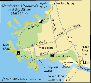
Mendocino Headlands
The Mendocino Headlands wrap around the quaint, coastal town of Mendocino, offering dramatic views of the rugged coast. Visitors can park at convenient spots around the headlands and stroll along trails as they enjoy the waves crashing against the islands and rushing through sea arches.
The Headlands have become a favorite place for whale watching during the winter migration months. The Headlands attract artists and photographers to the endless vantage points along the bluffs. Reach Portuguese Beach by a footpath and stairs off Main Street.
The Big River Unit
The Big River Unit, as it has been designated, consists of more than 7,000 acres along Big River. The property includes a popular beach, wetlands, and a long, scenic estuary. Canoeists and kayakers can paddle 8 miles up the gently flowing river.
Big River Beach is a broad, sandy expanse of white sand at the mouth of the river. Waves are constantly reshaping the beach. Access is via a road on the east side of Highway 1, immediately on the north side of the bridge. A parking area is located by the estuary and a short trail leads beneath the bridge to the beach.
Big River Estuary State Marine Conservation Area
The Big River Estuary State Marine Conservation Area extends from the Highway 1 bridge upstream about 1½ miles. Regulations permit the recreational take of surfperch (family Embiotocidae) by hook and line from shore only; and Dungeness crab by hoop net or hand is allowed.
Ford House Museum
The historic Ford House at 45035 Main Street in Mendocino serves as a museum and as the Visitor Center for Mendocino Headlands State Park. The house was erected in 1854 by Jerome B. Ford who was the superintendent of the first Mendocino sawmill. The museum has exhibits, historic photographs and relics from the early days of Mendocino. It is open daily from 11 AM to 4 PM. The Ford House is operated by the Mendocino Area Parks Association.
North of Mendocino
Point Cabrillo Light Station State Historic Park
The Point Cabrillo Light Station was erected in 1909 after damage to the Point Arena Lighthouse in the 1906 San Francisco earthquake. More than a dozen other buildings were also constructed as housing for the keepers and for storage. Today visitors park near the Visitor Center at the entrance off Point Cabrillo Drive and walk a little more than a half mile out to the point. The park is 3 miles north of Mendocino.
The park consists of the lighthouse, four historic houses and cottages which may be rented, a museum, a small blacksmith shop/marine science aquarium, and trails along the bluffs. Guided site tours are available on Sundays, and during the summer they offer four lantern room tours.
Information: (707) 937-6122.
See a map and read more about Point Cabrillo on the ACTIVITIES page.
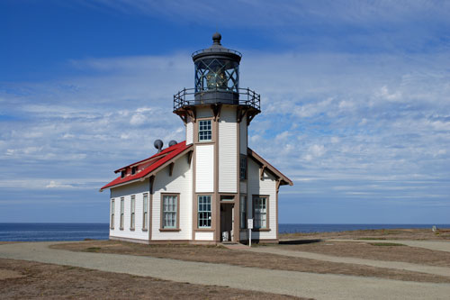
Point Cabrillo Light Station
Jug Handle State Natural Reserve
Located along the coast mid-way between Mendocino and Fort Bragg, Jug Handle State Natural Reserve features a 2½-mile self-guided nature trail known as The Ecological Staircase. The trail passes through wave-cut terraces that span 100,000 years of geologic history. Each terrace with its unique ecology. See a map and read more about Jug Handle State Natural Reserve on the ACTIVITIES page.