Big Sur Beaches

Andrew Molera SP Beach &
Pfeiffer Beach

Pfeiffer Beach, Big Sur, California

Big Sur Beaches

Andrew Molera SP Beach &
Pfeiffer Beach


Andrew Molera
State Park Coastline and Beaches

Andrew Molera State Park has about 3 mile of coastline running from Cooper Point in the south to just beyond the mouth of Big Sur River in the north. Most of the coast is composed of narrow band of rocky shoreline, too difficult and dangerous to access. The park is 21 miles south of Carmel.

There are, however, two sandy beaches within the park - the main beach at the mouth of Big Sur River and a smaller beach 2 miles to the south, accessed by Spring Trail.

Trails to the Beaches

  • Beach Trail: 1 mile from park entrance to the main beach at the mouth of Big Sur River. Virtually flat along the Big Sur River.
  • Bluff Trail: 1.7 miles from the Big Sur River beach (2.7 miles from parking lot). Add a short jaunt of the Spring Trail which involves some scrambling over boulders. Find yourself at a small beautiful beach.

Andrew Molera State Park, Big Sur,  CA

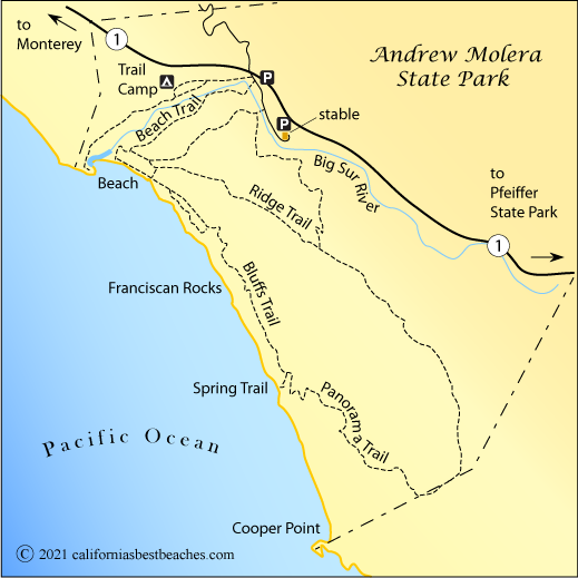
Andrew Molera SP Coastal Hikes

Ridge Trail: Climb about 1000 feet to the high points along the Ridge Trail for spectacular views of the surrounding coast and back over the Big Sur River Valley. 2-4 miles round trip, depending how far out the Ridge Trail you go.

Bluff and Panoramic trails: These connecting coastal trails offer numerous views of the ocean. From the main beach the full length of the combined trails is about a 6-mile round trip hike.

Hiking Cautions

Seasonal bridges on the Big Sur River are removed in the winter and crossing may be difficult or even unadvisable during periods of high run-off. Poison oak is prevalent along many of the trails. It is possible to hike south along the coast during low tide, but keep track of the time and the tide schedule to avoid being caught by the incoming tide. There are no restrooms at the beach. Carry water on longer hikes, especially on the Ridge Trail.

Pfeiffer Beach, Big Sur, CA

Pfeiffer Beach

Pfeiffer Beach, Big sur, CA

Pfeiffer Beach


Pfeiffer Beach

Pfeiffer Beach is operated by the US Forest Service. The number of vehicles permitted past the entrance station is limited. When the lots are full, new arrivals are held in a queue until space is available.

A short trail leads down to the beach. Look for purple sand, the result of manganese garnet deposits found in the surrounding rocks. Also find amazing rock formations, including several windows with waves crashing through them.

Pfeiffer Beach, Big Sur,  CA


Driving to Pfeiffer

Without a roadside sign to signal the turn to Pfeiffer Beach many people whisk along Highway 1 without even suspecting this hidden gem is there. The easiest way to find the turn onto Sycamore Canyon Road is to check your mileage as you pass the entrance to Pfeiffer State Park. 0.9 miles south of the park is a turnoff leading west. A yellow highway sign shows the intersection, but there is nothing else. A short way down the road you pass a sign that assures you are on the right track to the beach. The 2-mile road to the beach is narrow and warrants caution.

Picnicking at Pfeiffer

The massive rock at the mouth of the river at Pfeiffer Beach provides a convenient wind break. Picnicking on Pfeiffer in the lee of the rock is especially enjoyable. Waves crashing through passages in the rock provide ongoing entertainment. There is also a pleasant picnic area back by the parking lot. With the restrooms and parking lot only about 100 yards from the beach, it is convenient to move back and forth between the two locations.

  TOP


Ocean Safety

California State Parks and Recreation cautions that "large surf, cold water temperatures, backwash, sudden drop-offs, pounding shorebreak, and dangerous rip currents can turn what seem like safe activities such as playing near the surf line, wading, or climbing on rock outcroppings, deadly." Learn more about ocean safety at CA State Parks: Ocean Safety