Sharp Park Beach
Location
Highway 1, Pacifica, CA
San Mateo County
Sharp Park Beach is operated by the City of Pacifica.
Beach Hours
Pier Hours:
4:00 AM - 10:00 PM
Beach Hours: Sunrise to sunset
Pacifica Parks, Beaches & Recreation (650) 738-7381
Entrance fee: None
Main Attractions
- Picnicking
- Fishing
- Pier
Facilities
- Municipal Pier
- Walking promenade
- Nature trails
- Coastal Trail
- Parking
- Restrooms
Accessibility
- Parking
- Restrooms
- Pier
- Coastside Trail
Special Regulations
- Dogs on leash allowed on beach, but not on the pier
- No alcohol or glass containers
- No fires or BBQ grills on beach
Hazards Include
- Rip currents
- Heavy surf
Caution: Check with rangers or lifeguards that conditions are safe for your planned activities.
Half Moon Bay Tides
Tides.Info: Tide Predictions for Princeton, Half Moon Bay, California
Water Quality
San Mateo County Health System Water Quality Updates
Webcams
Sharp Park Municipal Pier
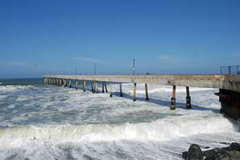
The 1,140-foot long, L-shaped municipal pier at Sharp Park in Pacifica is one of the most popular fishing locations along the coast. Built in 1973, the concrete pier has stood up against decades of heavy, pounding surf. Although it occasionally must be closed due to the surf, it is usually open from early morning until late at night, allowing anglers plenty of access.

Summer fishing is advertised as the best season, but experienced anglers have found success in the winter when the pier is almost deserted. Fishermen pull in salmon and striped bass, along with a variety of other ocean species such as surfperch and jacksmelt. No fishing license is required to fish from the pier. The pier can become crowded during the recreational Dungeness Crab season which usually begins the first Saturday of November.
Pacifica's municipal pier is equipped with lights, restrooms, benches, fish cleaning stations, and the Chit Chat Cafe at the Pier (a coffee house/snack bar) at the entrance.
Pier Rules
City regulations do not allow alcohol, smoking, dogs, or glass containers on the pier. Cycling and overhead casting are also prohibited.
Pier Poetry
The Pacifica Pier Poetry Walk was held on April 14, 2012. Participants were asked to write two lines of poetry that represented their feelings about the pier. Awards were presented at the end of the month to winners in various age groups.
Surf Fishing
While the pier is famous for its excellent fishing, those casting into the surf along Sharp Park Beach have had great success too. The area was once known for its striped bass, but the number of catches has fallen off in recent years. Still, fishermen on the beach land good-sized surfperch, including calico surfperch, redtail surfperch, and barred surfperch.
Surfing Sharp Park Beach
Shifting sandbars move the break around. During the winter Sharp Park has the reputation of being fierce. Currents are difficult to deal with. Padding out is hard and returning to the beach is often a challenge. Most surfers find the best waves there in spring or fall.

Metal skewers poking out of the sand near the drainage pipe closest to the pier are a particular hazard.

Sharp Park Beach
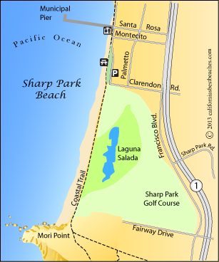
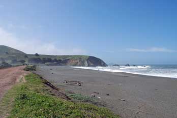
Sharp Park Beach extends along the waterfront on either side of the municipal pier, but little exposed sand is to be found north of the pier. Sea walls, intended to prevent erosion, have been blamed for the disappearance of the beach. To the south of the pier a long strand of black sand extends all the way to Mori Rock. Inland from the beach is Sharp Park Golf Course.
the Coastal Trail leads along the berm between the beach and the golf course, providing a pleasant walking path. Surfers venture out into the waves, but the area has a reputation for powerful and dangerous surf. Most visitors prefer to relax on the sand or the grassy picnic area a couple of blocks south of the pier.
Along the Coastal Trail
An abundance of wildlife can be seen by those who explore the trails along the shore of Sharp Park Beach. Birds are everywhere - gulls and sandpipers, brown pelicans and mallards. Off shore watch for harbor seals bobbing their heaps up around the pier and beyond the surf line. Sea lions are often seen in the area. Gray whales pass a little farther out on their winter migration.
Beyond the immediate beach turn inland to Laguna Salada, a wetlands lake with tules and cattails. If you are lucky you might sight an endangered San Francisco garter snake or a California red-legged frog. Nearby stand Monterey Cypress. In the spring the area comes alive with wildflowers.
By continuing south you can connect with the trails at Mori Point.

Mori Point
Mori Point is part of the Golden Gate National Recreation Area. Several trails lead up to the ridge at the summit of Mori Point, offering wonderful views of the area. Two trails, the Polly Wog Trail and the Loop Trail are accessible. A raised boardwalk is wheelchair accessible and provides access to benches. The hike to the top of the ridge is a 1.5-mile, steep trail. Parking can be found on Mori Point Road and on Bradford Way.
Books of Local Interest
Ocean Safety
California State Parks and Recreation cautions that "large surf, cold water temperatures, backwash, sudden drop-offs,
pounding shorebreak, and dangerous rip currents can turn what seem like safe activities such as
playing near the surf line, wading, or climbing on rock outcroppings, deadly."
Learn more about ocean safety at
CA State Parks: Ocean Safety
California's Best Beaches
Every effort is made to provide accurate and up to date information, but we cannot be responsible for errors or for changes that may have occurred since publication. Always confirm information with the service provider and check for any recent changes that may have been made. Also, check with lifeguards that conditions at the beach are safe for your planned activities.
The map displayed above is for illustrative purposes only. California's Best Beaches website makes no warranties regarding the accuracy, completeness, reliability or suitability of any of its maps. The information provided on this website is done so without warranty of any kind, either expressed or implied, including but not limited to, the implied warranties of merchantability and fitness for a particular purpose.

