Schooner Gulch Beach & Bowling Ball Beach
Mendocino County

Schooner Gulch State Beach
Location and Hours
- At Schooner Gulch Rd.
3 miles south of Point Arena, CA - Highway 1 mile marker 11.3
- Open sunrise to sunset
- (707) 937-5804
- Free
Main Attractions
- Scenic vistas of ocean and coast
- Interesting geologic formations
- Tide pools
- Picnicking
- Surfing
Facilities
- Parking are along Highway 1
- Trails
- Portable toilet on Schooner Gulch trail (poorly maintained)
Accessibility
- Parking lots
Special Regulations
- No glass on the beaches
- Stay on trails
Hazards Include
- Dangerous waves
- Strong rip-currents
- Eroding cliffs
- Eroded trails
Caution: Check with rangers or lifeguards that conditions are safe for your planned activities.
Webcams
Point Arena Webcam
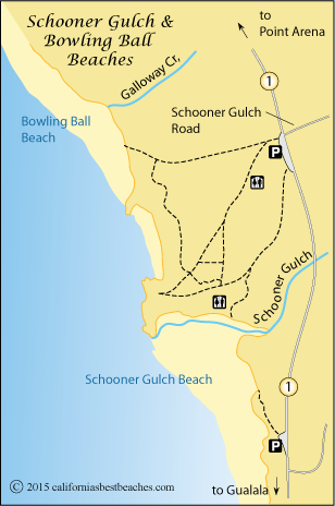
Schooner Gulch and Bowling Ball Beaches
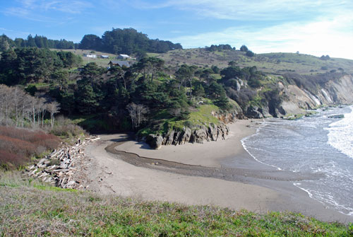
Schooner Gulch is a small, pleasant beach with tide pools and interesting rock formations. Its neighbor, Bowling Ball Beach, draws much more attention because of the rows of spherical rock balls visible at low tide and other interesting geologic formations.
Parking is found along the southbound side of Highway 1 at Schooner Gulch Road. Because of a blind curve coming from the north, drivers should plan to approach the parking area from the north and exit to the south. Another parking area is slightly south of Schooner Gulch.
Trails lead from the main parking area to both Schooner Gulch Beach and Bowling Ball Beach. Erosion has degraded the trail to Bowling Ball Beach so that park officials have declared it closed. Even so, some people make their way down slippery, muddy steps at their own risk, using a make-shift rope for support. It is not recommended.
Bowling Balls on the Beach
The spherical rocks on Bowling Ball Beach attract sightseers, geologists, and photographers. Lined up nearly in rows on the beach, the sandstone balls are about 2 to 3 feet in diameter. These sedimentary rocks were formed when mineral cements bound grains of sand or stone into larger formations. These bowling ball rocks are known as concretions.
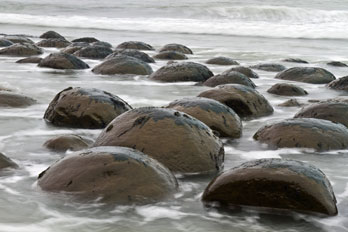
The concretions were formed inside the softer Cenozoic mudstone of the bluffs along the coast. As the surrounding stone was worn away by waves, the concretions were exposed.
Farther north along the beach are concretions which have taken a different shape. Resembling giant English muffins, the rocks are pressed against the face of the cliff where they have gradually been exposed by the pounding waves. Some are still attached to the slope of the cliff while others have slid down to rest on the edge of the beach.
Schooner Gulch
The Schooner Gulch beach features its own interesting rock formations along the cliffs. A broad expanse of sand allows plenty of rooms for family gatherings, beach games, and picnicking. At low tide the tide pools are exposed. At very low tides it is possible to hike from Schooner Gulch Beach around the points to Bowling Ball Beach.
Reportedly, Schooner Gulch earned its name from a story in which one evening a schooner was spotted stranded on the beach. When morning came, however, visitors on the beach could find no evidence of the vessel ever having been there.
Saunders Reef State Marine
Conservation Area
The Saunders Reef State Marine Conservation Area begins immediately south of Schooner Gulch State Beach, at mile marker 11 along Highway 1 and extends south about 4 miles to Slick Rock Creek. Within the Conservation Area all living marine resources are protected. The only recreational fishing allowed in the Conservation Area is trolling for salmon. Fishing is allowed along Schooner Gulch and Bowling Ball Beach.
California State Marine Protected Areas
Nearby Beaches
Books of Local Interest
Ocean Safety
California State Parks and Recreation cautions that "large surf, cold water temperatures, backwash, sudden drop-offs,
pounding shorebreak, and dangerous rip currents can turn what seem like safe activities such as
playing near the surf line, wading, or climbing on rock outcroppings, deadly."
Learn more about ocean safety at
CA State Parks: Ocean Safety
California's Best Beaches
Every effort is made to provide accurate and up to date information, but we cannot be responsible for errors or for changes that may have occurred since publication. Always confirm information with the service provider and check for any recent changes that may have been made. Also, check with lifeguards that conditions at the beach are safe for your planned activities.
The map displayed above is for illustrative purposes only. California's Best Beaches website makes no warranties regarding the accuracy, completeness, reliability or suitability of any of its maps. The information provided on this website is done so without warranty of any kind, either expressed or implied, including but not limited to, the implied warranties of merchantability and fitness for a particular purpose.