Point Arena Lighthouse
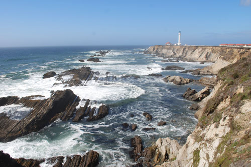
The original lighthouse at Point Arena was erected in 1870. It included a large keepers' residence. The 1906 San Francisco earthquake damaged both the lighthouse and the residence so severely that they had to be dismantled. The new lighthouse, built to withstand earthquakes, was completed in 1908.
The lighthouse stands 115 feet tall. Over the years the inner works of the lighthouse have undergone many changes. The Point Arena Lighthouse Keepers, a nonprofit organization, took over ownership of the property in 2000.
Lighthouse Tours
Guided tours of the light station museum and tower will be offered daily once the COVID-19 pandemic has passed. The tours include ascending to the top of the tower and stepped out onto the balcony for spectacular views of the area. Self-guided tours of the grounds and outdoor museum are now available. The store and indoor museum are open.
Hours: 10:00 AM to 4:30 PM in summer, closing at 3:30 PM after Labor Day until Memorial Day. Closed Thanksgiving and Christmas.
Site Admission Fee: adults $5, children under 12 free
The lighthouse grounds include a gift store. Visit our LODGING page for information about overnight accommodations at the Point Arena Lighthouse.
Lighthouse Lecture Series
A series of programs about natural history of the area and other similar topics are offered throughout the year. Topics have included elephant seals, local Native American stories, gray whales, sea birds, and local art. Programs are held at the Fog Signal Building at the lighthouse.
Point Arena Lighthouse and Museum
Point Arena Webcam
Manchester State Park and Point Arena Hiking Trails
Besides the obvious walk along the 5 miles of beach at Manchester State Park there are a number of small trails that are worth investigating.
Caution: Check with rangers or lifeguards that conditions are safe for your planned activities.
Alder Creek Trail - Park in a day-use area at the state park's campground and set out on 4-mile round-trip hike to the mouth of Alder Creek. Along the way are several signs giving information about wildlife in the area. The trail passes Lake Davis and continues up the beach to the creek. Alder Creek can also be reached by parking at the entrance to Alder Creek Road (closed to vehicle traffic) and walking down the road.
Stoneboro Road to the Beach - Park at the Stoneboro Road Day-use Area parking lot and hike west ½-mile to the beach.
Point Arena - Stornetta Public Lands
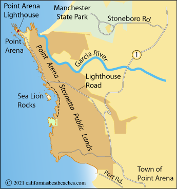
Point Arena - Stornetta Public Lands are 1,665 acres of federal land surrounding Point Arena and extending south along the coast. The land is administered by the Bureau of Land Management and is open to the public.
Point Arena - Stornetta Public Lands Map

Parking: Parking is permitted along Lighthouse Road at pull-outs. Porta-toilets are provided. No water is available. Parking is also available at the Point Arena City Hall. Limited parking is permitted at the end of Miner Hole (County) Road; however, the road is currently closed to vehicles approximately .1 mile from Highway 1.
Cautions: Hazards include sink holes and unstable cliffs. Offshore rocks that are accessible at low tide can be underwater at high tide.
Hiking Trails: One of the best hikes in the Stornetta area begins at a turnout on Lighthouse Road near where it first reaches the coast. From there a trail leads south for a mile along the bluffs with views of Sea Lion Rocks and the rugged shoreline.
Another hike begins at Highway 1 just north of the town of Point Arena and leads west 1¼ miles to the point of land north of Arena Cove.
Horseback Rides
Ross Ranch offers guided horseback riding tours on Manchester Beach or through nearby redwood forests.
Ross Ranch
Stand on The San Andreas Fault
The San Andreas Fault extends over 800 miles beneath California from the Salton Sea in the south to Cape Mendocino in the north. The fault is best known as the source of the 1906 San Francisco Earthquake.
Around Point Arena the fault is located beneath the Garcia River bed 2 miles east of Highway 1 near Mountain View Road. Heading south, the fault follows the river for miles. To the north, the fault line leaves the river where it bends to the west and continues in a northwesterly direction, crossing Highway 1 near Kinney Road and passing off the coast south of Alder Creek.
Visitors who have walked up the trail from the Manchester State Park campground to Alder Creek have noted a change in the landforms that could indicate the fault line as they neared Lake Davis. During the summer Lake Davis is hardly more than a pond, but as the rains return in the winter the lake swells.
Fishing at Manchester State Park
Brush Creek and Alder Creek are popular steelhead trout and salmon fishing streams. California Freshwater fishing regulations state that fishing is allowed from the fourth Saturday in May through March 31. Only artificial lures with barbless hooks may be used during that time. Only barbless hooks may be used from November 1 through March 31. Streams may be closed to fishing due to low water flow.
Check for the most up-to-date information at California Department of Fish and Wildlife Hunting and Fishing Regulations

